See How They Run |
|
Timezones, Transport, Robovord, Map Links, Other Links |
|
Relative Timezones |
|
|
|
In English, relative to UK, Ireland & Portugal Central Europe Other countries |
|
In Finnish, relative to Finland & Estonia Central Europe Other countries |


|
Transport Resources |
|
|
|
London Underground Tube Station Maps |
|
|
Cornwall and Devon railway map (Southwest England) (18k) |
|
|
Docklands Light Railway map (London) (53k) |
|
|
DLR City Airport extension track map (London) (11k) |
|
|
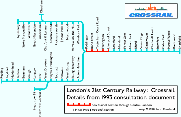
CrossRail map (London) (21k) : see TPftLA for planning updates |
|
|
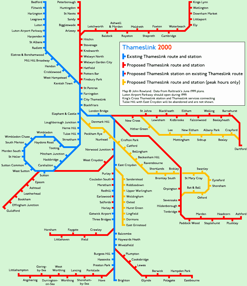
Thameslink 2000 map (London & the Southeast) (47k) : see TPftLA for planning updates |
|
|
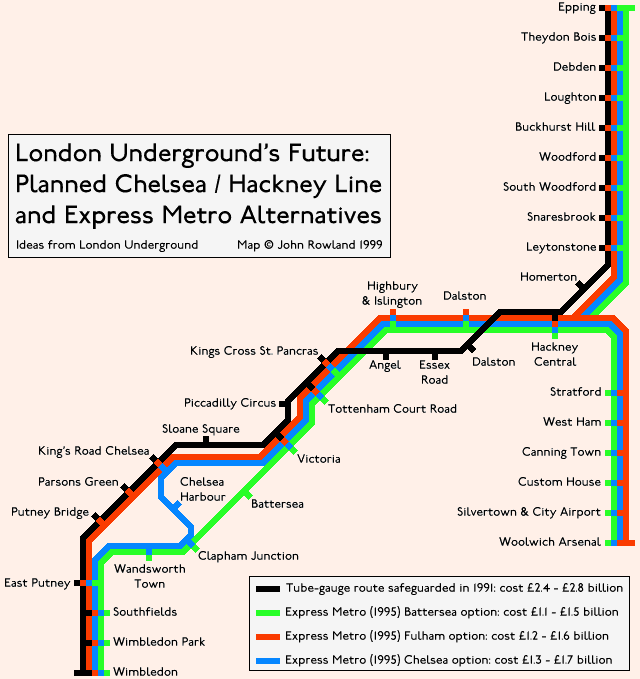
Chelsea / Hackney Line options map (London) (35k) : see TPftLA for planning updates |
|
|
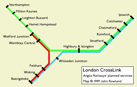
Anglia Railways' London CrossLink map (8k): see TPftLA for planning updates |
|
|
Transport Enthusiasts' London - list of bookshops, fairs and society meetings |
|
|
Transport Plans for the London Area : progress reports on 200 schemes. Planned Underground Lines, reopening railways, tramways under construction, new interchanges, step-free stations, proposed express buses, river services, airport expansion, trunk road construction, pedestrianisation |
|
|
London Underground Service Frequencies : which line has a train every 2½ minutes every day? Are all the Metropolitan trains the same length? Which line has only 2 trains in service on Saturday? At which termini do drivers "step back"? |
|
|
Metropolitan Line services, tracks and train indicators : the Underground's most confusing line |
|
|
Sharing the Circle : how many District trains join the Circle Line at Tower Hill, and how many leave at Gloucester Road? |
|
|
Outer London's most used stations : an ordered list. Not interesting - for information purposes only |
|
|
WAGN Wheels : facilities and wheelchair access at West Anglia Great Northern stations in London and outside London |
|
|
David Connor's Tribute to the Victoria Line |
|
|
A Car-free London? : my submission to the Architecture Foundation competition |
|
|
Atlases in London Libraries : where can you view a Berlin transport atlas and the Routledge Atlas of the World's Languages? |
|
|
Huge Maps : Manchester, Helsinki, Vancouver, Bosnia etc. |
|
|
Paris Metro frequencies |
|
|
Guestbook : go on, make me smile! |


Robovord |
|
|
|
ROBOVORD - your own number-crunching Northerner. Watch The Vord On The Circuit Board beat the wetware version. This Java applet will work even when you are not connected to the Internet, for instance at 4:40pm and at 4:50pm. It works in Netscape, but for maximum speed use MSIE with the latest free Java Virtual Machine |

Map Links |
|
|
|
Copenhagen: Pulse Of The City: click on Byens Puls
for a dynamic tube-style map. For Netscape or the latest MSIE. Copenhagen observes Central European Time: trains run between 5am (6am on Sunday) and 1am. Here's a track map |
|
|
Morphing tube map, geographic to geometric and back... requires Macromedia Flash |
|
|
San Francisco Muni Metro: a dynamic map: Piers Connor of the Railway Technical Web Pages describes thus - "It is a diagram of the tunnel section of the light rail system under Market Street between Embarcadero and the station beyond Van Ness. The initials refer to the platforms: "VNR" is Van Ness Right platform. The letters above the white blocks are the route letters of the LRVs. Some split so there are two different letters for one train." |
|
|
Tokyo Metro station in VRML 3D - click "Study", then click and drag the object |
|
|
Geographic Tube Map on the London Transport site |
|
|
London Connections map of tubes, trains and trams: new version by JonE and old version by Jim Mangles |
|
|
Greenwood's Map of London - from the year 1827 (the map, not the website) |
|
|
British railway map: shows every passenger and freight line but unfortunately doesn't show stations! |
|
|
UrbanRail.Net: Robert Schwandl's astonishingly comprehensive resource covering every metro in the world |
|
|
American and other cities: Robert Reynolds' collection |
|
|
Russian and other cities: Dmitry Zinoviev's collection |
|
|
The world's first geometric railway map: Harry Beck's Tube Map from 1931, 1937 and 1951 |
|
|
Step-free Underground: How much of the Tube is accessible to wheelchair-users? |
|
|
Quail Maps - detailed track diagrams of the Underground, British and foreign railways |
|
|
Other Links |
|
|
|
Clive's Underground Line Guides : the famous CULG. The definitive fan site for Tube history (text only) |
|
|
Richard Griffin's pictures of Underground stock : the best pictures of Underground trains on the web |
|
|
A DLR fan site that looks so good that the BBC News thought it was the official DLR site! |
|
|
"Mind The Gap" recording |
|
|
Press archives of London Transport and Department of Transport (British government) |
|
|
London Underground Railway Society - hold a monthly meeting and produce a monthly booklet |
|
|
Electric Railway Society - hold a monthly meeting and produce a bi-monthly booklet |
|
|
Links to 81 British Isles webcams |
|
|
The world's most busy airports (in passengers per year) |
|
|
Map and links to London's borough councils |
|
|
InfoLondon : Astonishingly complete and up-to-date transport news for London |
|
|
Personalised railway timetables for South London and Sussex |
|
|
Personalised railway timetables for Southeast Queensland : Ask for times from Tennyson to Robina to see a complicated example |
|
|
Internet Movie Database : the IMDB has even the most obscure bit-parts in the most obscure films |
|
|
BBC2 idents fan page : It's got the one with the swan, and the barking "2" that does somersaults |
|
|
The Pagliameter - Camille Paglia or not? |
|
|
Today's Calendar and Clock Page |
|
|
Free flying flags courtesy of The Page |
|
|
RailServe: The Internet Railroad Directory : 2,000 links, search engine, forums, chat rooms, and more |
 |
Updated 2006-03-07 |
|